How to add and configure placemark attachments on PC
Posted on Categories Common Features
1. Purposes of placemark attachments:
Placemark attachments are used to expand the information of placemarks, including documents, images, and audio/video files. You can set placemark attachments to be displayed on the map if needed.
2. How to add and configure placemark attachments
In the placemark settings, click [Set Attachments] to go to the [Placemark Attachment Settings] dialog box.
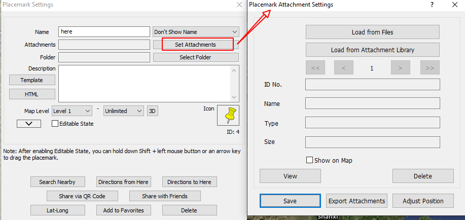
Load from Files: Load the required files directly from the local disk and adds them to the placemark attachment library.
Load from Attachment Library: Select attachments from the attachment library.
> (Next): Click to add or view the next attachment. A placemark can have a maximum of 100 attachments.
Show on Map: If the first placemark attachment is an image, you can select [Show on Map] to demonstrate it on the map.
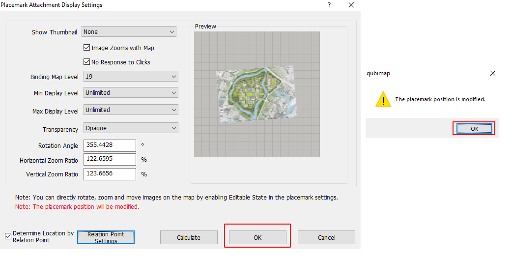
Display Settings: Click [Display Settings] to configure the display settings of the image attachment, as shown in the following figure:
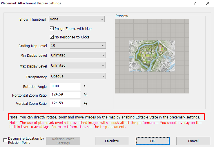
You can set the display position of the image attachment by performing the following steps:
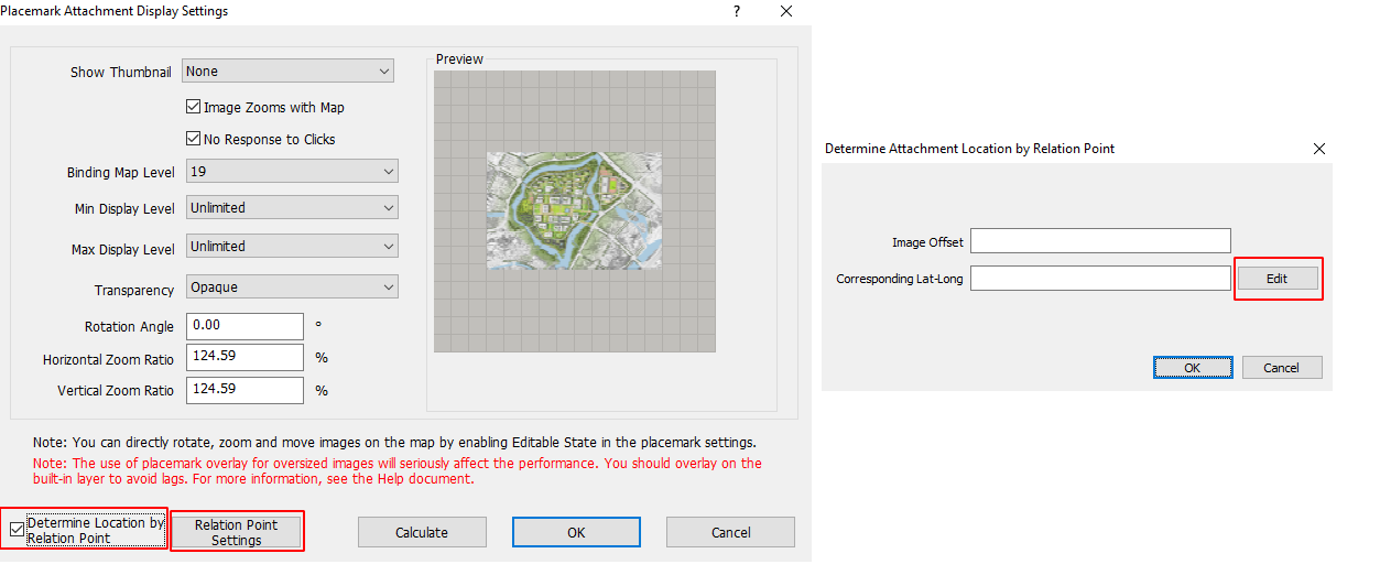
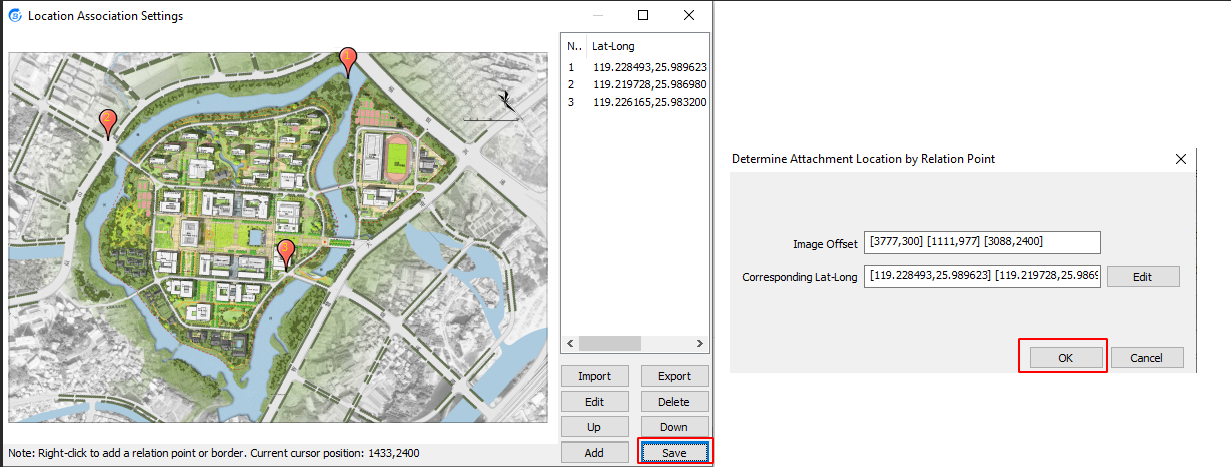
In the [Placemark Attachment Display Settings] dialog box, select [Determine Location by Relation Point] and then click [Relation Point Settings].
In the [Determine Attachment Location by Relation Point] dialog box, click [Edit].
In the [Location Association Settings] dialog box, right-click at the required location on the image attachment, and select [Add Relation Point] to add Relation Point 1. In the [Edit Association Point: 1] dialog box, click [Set Lat-Long on Map], move the mouse cursor to the map window to locate Relation Point 1, right-click it to retrieve the latitude and longitude, and then click [Save]. We recommend that you set 2 or 3 relation points that are distributed at the four corners.
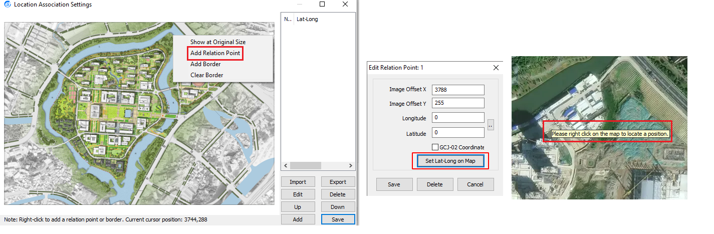
After all relation points are added, click [Save] → [OK].
In the [Placemark Attachment Display Settings] dialog box, click [OK] → [OK].
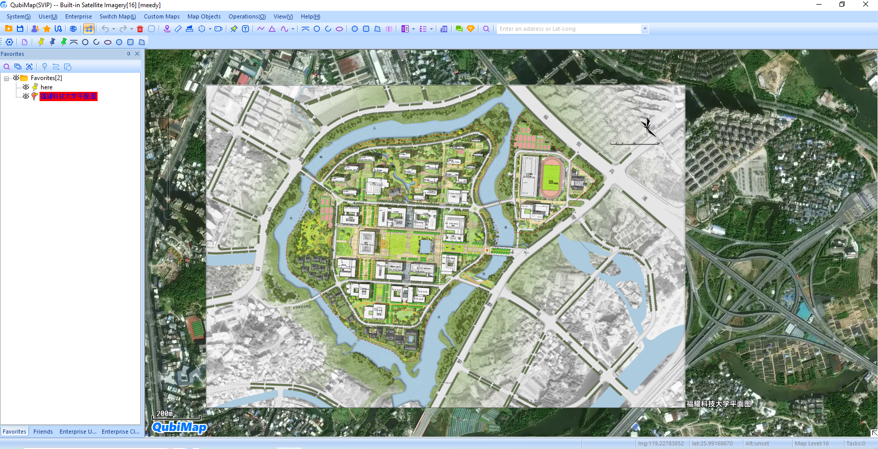
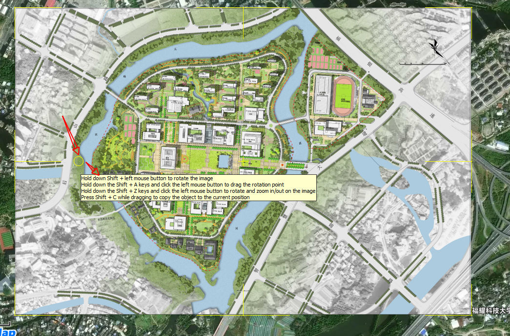
The image attachment will be displayed on the map based on the previously set parameters, as shown in the following figure:
Note: If an image is very large in size, we do not recommend that you demonstrate it on the map by setting it as a placemark attachment. Otherwise, the performance may be tremendously compromised. You can overlay it on a built-in layer to avoid system lags. For more information, see the help document “How to import custom aerial images and set overlays“.
Transparency: Set the transparency degree of the image. This is typically needed when you demonstrate design drawings as placemark attachments on the map).
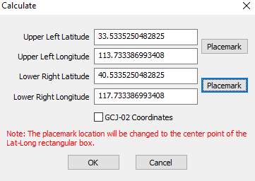
Calculate: Set the latitude and longitude of the top-left and bottom-right corners of the image, so that it can be displayed on the map at the specified location. This feature is applicable when the latitude and longitude of these two corners are already known.
After you enable Editable State in the placemark settings, you can directly edit the image on the map, such as select, zoom, and move.

3. Placemark Attachment Library
You can manage placemark attachments in the placemark attachment library. On the main UI, choose [System] > [Data Management] > [Placemark Attachment Library Management].
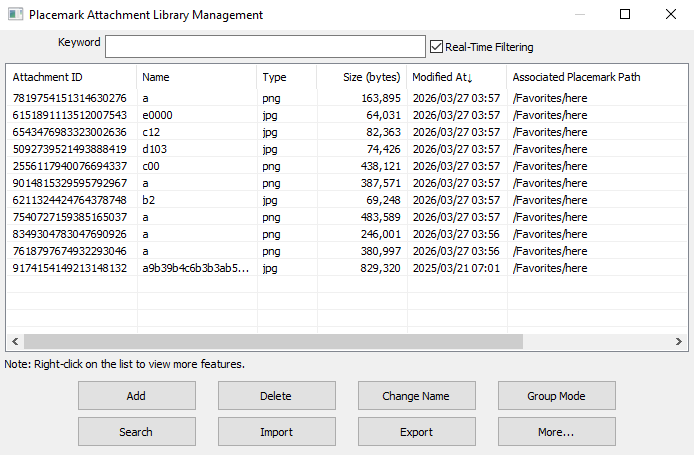
Add: Add a local files to the placemark attachment library.
Delete: Delete the selected placemark attachments.
Rename: Rename the selected placemark attachment.
Group Mode: Display placemark attachments in group or list mode.
Search: Search for attachments by name, time, or placemark.
Attachment Association: Specify the application to open for each type of placemark attachments.
Import: Import .ovobj files from local storage to the placemark attachment library. Attachment IDs remain unchanged, and if the attachments are already added to placemarks, the paths of the associated placemarks are automatically displayed in the list.
Export: Export placemark attachments from the attachment library to the local disk as .ovobj files.
The latest versions of QubiMap supports automatic association of placemarks and attachments, so that you do not need to handle attachments while syncing or uploading placemarks.